How mapping supported risk analysis for Plymouth evacuation
In an emergency, accurate mapping and location data becomes a vital tool in decision making and planning responses.
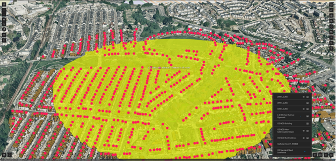
A major incident was declared, and the Police evacuated properties within 300 metres of the bomb affecting more than 10,000 people.
Initial assessments showed a significant risk to public safety, prompting the biggest evacuation since WW2, and requiring swift and informed action. Knowing exactly which houses and residents to evacuate was decided using OS mapping and addressing data.
Contingency planning and risk analysis
DCP was tasked with delivering a 3D model of the immediate area and requested OS support via Mapping for Emergencies – an OS service offered to the resilience community to provide geospatial support during an emergency or major incident.
The initial objective was to map the evacuation area. It was important for the public to see the areas affected, and to provide public confidence and awareness of why they were being asked to evacuate from their homes. Blast zone mapping helped to build best- and worst-case scenarios in the military's risk analysis when determining whether the bomb was detonated in situ or moved to a safe detonation site.
Building a 3D model
DCP deployed drones to fly to the site, and create an up-to-date 3D model of the area. This data was shared with OS, to integrate both OS’s data and DCP’s 3D models together. The OS 3D team rapidly developed an interactive online tool that enabled users to view and interact with a 3D model of the area. The collaborative model was augmented with other datasets including base mapping, cordon extents – the 300m evacuation zone – and address data for the properties contained within.
The online tool was designed to be viewed on any device, from any location. It was then shared via Resilience Direct – a platform that enables real-time sharing of information with emergency responders, and public- and private- sector organisations. This in turn informed the military, internal departments, and local resilience groups. The combined efforts of DCP and OS achieved fast-paced decision making, and access to the data model also fortunately meant that the number of personnel within the cordon could be reduced.
Result and conclusion
The DCP/OS online tool allowed users to see the data instantly, from any phone, tablet, or PC, from anywhere in the country; condensing critical information and insight in a single online location hosted by OS.
The tool could then be accessed and used by multiple agencies – the MoD, Coastguard, Plymouth Council, Devon & Somerset Fire and Rescue Service. All could be involved and informed in their own planning and reaction.
With key partners notified, the use of geospatial data helped deliver a safe, effective evacuation and removal of the bomb.
Need further support?
Contact us for direct help with your PSGA membership

Our highly accurate geospatial data and printed maps help individuals, governments and companies to understand the world, both in Britain and overseas.
Products and solutions featured in this blog
AddressBase
AddressBase matches 29 million Royal Mail postal address to unique property reference numbers, bringing a new dimension to the matched records.
OS Maps API
Accurate, up-to-date maps that offer the most convenient way to add detailed OS data to your application.